
September 30, 2016 — Kīlauea
Kamokuna ocean entry continues

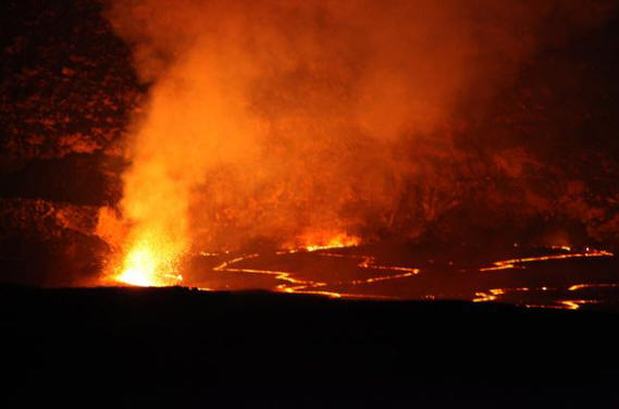
Lava continues to flow into the ocean at Kamokuna,
however this afternoon there was no noticeable plume at
the western delta (upper left). The eastern delta
(center) is larger, with lava continuing to enter the
ocean. A relatively small area of surface breakouts is
active on the coastal plain about 1.5 km (0.9 miles)
upslope from the ocean entry.

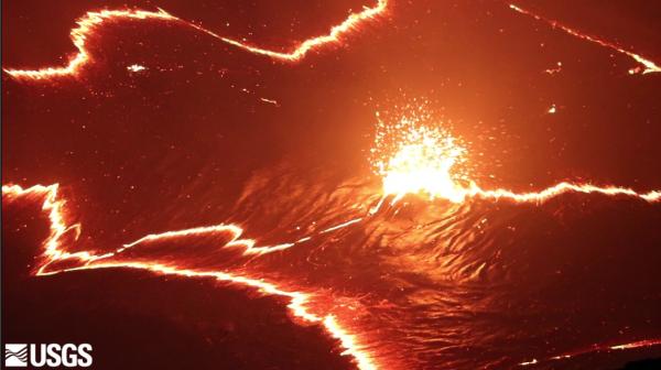
Left: Photo of the eastern delta showing the cracks
parallel to the sea cliff. The delta is about 350-400 m
(1150-1300 ft) wide and it extends about 150 m (490 ft)
out from the old sea cliff. Deltas are unstable, and
prone to collapse, because they are built on
unconsolidated lava fragments. Right: Thermal image of
the eastern delta showing heat in the cracks, as well as
plumes of hot water (up to 70 degrees Celsius, or 160
degrees Fahrenheit in this image) extending out from the
entry points.

A large skylight was open today on the 61g upper flow
field. This morning, only the narrow skylight on the
left was open. Hours later the larger area collapsed and
exposed more of the swiftly moving lava stream in the
tube. In this image, the skylight is about 5 m or 16
feet wide.

Another view of the larger skylight, about 5 m or 16 ft
across, showing the thin roof on the tube in this area.
This image is a reminder of the hazard of approaching
skylights.
September 28, 2016 — Kīlauea
Halemaʻumaʻu at dusk

A view of the lava lake in Halemaʻumaʻu Crater at dusk,
taken from the rim of Halemaʻumaʻu (closed to the public
due to volcanic hazards). The view is towards the
northwest, with the broad summit of Mauna Loa near the
top of the photograph. The lake was 34 meters (112 feet)
below the Overlook crater rim at this time.
This video clip shows the northern portion of the lava
lake, where episodic bubbling commonly occurs. The
northern margin of the lake is in the upper right
portion of the photo. Note how the bubbling occurs in
the same general area, regardless of the movement of the
crustal plates. The video is shown at 20x speed.
September 27, 2016 — Kīlauea
The rise and fall of Kīlauea Volcano's summit lava lake

Since early September 2016, Kīlauea's summit lava lake
level has fluctuated, as shown in these side-by-side
webcam images. On September 10 (left), the summit lava
lake rose to within 5 m (16 ft) of the vent rim, only to
drop the next day with the onset of summit deflation.
Since then, the lava lake level has been up and down in
concert with summit inflation and deflation, dropping to
30 m (98 ft) below the vent rim on September 24
(right)—and as low as 36 m (118 ft) the next day. For
insight on what's happening with Kīlauea Volcano's
summit lava lake and what it means, check out this
recent HVO "Volcano Watch" article—http://hvo.wr.usgs.gov/volcanowatch/view.php?id=456.
To track the summit lava lake activity, please visit
HVO's webcam images at http://hvo.wr.usgs.gov/cams/.
September 20, 2016 — Kīlauea
Breakouts remain active on the coastal plain

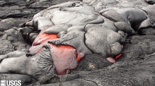
Breakouts from the the 61g lava flow remain active on
Kīlauea Volcano's coastal plain, roughly 2 km (1.2
miles) upslope of the ocean entry. This photo shows a
typical lobe of pāhoehoe lava filling in a small
depression.
This video clip shows a few of the lava breakouts active
on Kīlauea's coastal plain on September 20. The activity
consisted of scattered pāhoehoe breakouts. The final
segment in this video is shown at x20 speed.
Kīlauea's summit lava lake on the rise again


Left: During recent summit deflation, the lava
lake within Halemaʻumaʻu Crater dropped out of view of
overlooks in Hawaiʻi Volcanoes National Park. But since
the switch to inflation early Sunday morning (September
18), Kīlauea Volcano's summit lava lake has been rising
again, bringing the lake surface back into view. This
morning the lake level was measured at 12 m (39 ft)
below the vent rim, with sporadic spattering visible
from the Park's Jaggar Museum Overlook. Right:
This telephoto image provides a closer view of the lava
lake within Halemaʻumaʻu Crater and spattering on the
lake surface.
September 16, 2016 — Kīlauea
Views of the eastern Kamokuna lava delta

Under trade wind conditions, Kīlauea Volcano's eastern
Kamokuna lava delta is more safely viewed from outside
the closed area on the east, or Kalapana, side of the
ocean entry. Today, trade winds were blowing the billowy
white ocean entry plume, a mixture of superheated steam,
hydrochloric acid, and tiny shards of volcanic glass,
away from the viewing area. Noxious volcanic fume from
the active lava tube, visible to the right of the plume,
should also be avoided by staying upwind of the ocean
entry, which today, was at this location.

A telephoto image of the eastern Kamokuna lava delta
(from the same location as the photo above) shows lava
dribbling into the sea and a closer view of the ocean
entry plume.
September 12, 2016 — Kīlauea
Ocean entry and breakout on the coastal plain continue

Lava continues to flow into the ocean at Kamokuna, with
two main entry areas, both forming lava deltas. The
eastern lava delta is the larger of the two, and today,
a broad span of small lava streams entering the sea was
creating a wide ocean entry plume. The smaller western
entry was feeding a weaker plume.


Left: Another view of the ocean entries, with the
eastern entry in the foreground. For scale, a boat can
be seen in the lower left portion of the image.
Right: A breakout from the base of the pali, which
began last week, remained active today, with scattered
pāhoehoe lobes near the eastern margin of the 61g lava
flow. Fume from the lava tubes on the pali can be seen
in the upper left part of the image.
Kīlauea's summit lava lake remains at a high level

The lava lake at the summit of Kīlauea remained at a
high level today, about 18 m (60 ft) from the floor of
Halemaʻumaʻu Crater at the time of this photo.
September 10, 2016 — Kīlauea
Halemaʻumaʻu lava lake exceptionally high


Left: Kīlauea's summit lava lake rose to within
about 5 m (16 ft) of the floor of Halemaʻumaʻu Crater
this morning, before dropping back down slightly with
the onset of spattering. This view, taken from the east
edge of Halemaʻumaʻu, shows spattering at the south
corner of the lava lake. Right: Zoomed in view of
the spattering at the south edge of the lava lake. Note
the black high-lava mark from this morning on the wall
just behind the spattering.

View of Kīlauea's summit lava lake from the north rim of
Halemaʻumaʻu.
Movie showing lava lake spattering

Movie showing spattering near the south edge of
Kīlauea's summit lava lake in Halemaʻumaʻu.
September 8, 2016 — Kīlauea
Ocean entry activity continues

Lava continues to flow into the sea at the Kamokuna
ocean entry. This photograph, taken from the eastern
margin of the lava flow, shows the eastern ocean entry
site and the lava delta that has formed there. Today,
several small streams of incandescent lava could be seen
spilling into the water, with occasional small explosive
bursts occurring in the surf.
September 7, 2016 — Kīlauea
Kīlauea's lava lake at high level

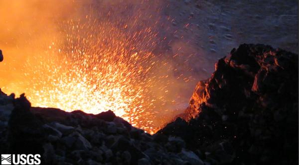
On Wednesday evening (September 7), the lava lake at
Kīlauea's summit reached a high level, about 8 m (26
feet) below the floor of Halemaʻumaʻu Crater. This
panorama shows the former Halemaʻumaʻu Overlook (closed
since 2008 due to volcanic hazards) at the far left.
Jaggar Museum, visible on the skyline in the upper right
part of the photo, is a popular destination in Hawaiʻi
Volcanoes National Park for viewing the lava lake
activity and spattering lake surface.

A closer look at Kīlauea's summit lava lake on Wednesday
evening, around 6:30 p.m., when the lake was just 8
meters (26 feet) below the floor of Halemaʻumaʻu Crater.
A video clip showing spattering in Kīlauea's summit lava
lake.
September 6, 2016 — Kīlauea
Beautiful morning at the summit of Kīlauea

Kīlauea Volcano's lava lake within Halemaʻumaʻu Crater
rose steadily over the past day in concert with summit
inflation. This morning, with the lake level at just 19
m (62 ft) below the summit vent rim, vigorous spattering
on the lake surface was visible from the Jaggar Museum
Overlook in Hawaiʻi Volcanoes National Park.
September 1, 2016 — Kīlauea
Beautiful day on Kīlauea Volcano's East Rift Zone


Left: Calm after the storm—a beautiful day on
Kīlauea Volcano's East Rift Zone. Rain from Hurricane
Madeline had little impact on Puʻu ʻŌʻō, shown here, or
lava flow 61g. Right: View of the lava pond
within the Puʻu ʻŌʻō west pit crater, which is about 50
m (164 ft) across. Weak spattering on the lava pond
surface, about 23 m (75 ft) below the crater rim, is
visible through the thick volcanic gas cloud.


Left: An aerial view of a new breakout
(light-colored flow at center of image) from the 61g
tube. The breakout began with some vigor on the morning
August 29, but today it was sluggish, with only a few
scattered pāhoehoe toes still active on the margins of
the flow. Right: Close-up view of one of the
small toes of pāhoehoe still active on the new breakout
from the 61g lava tube, which began on Monday, August
29.


Left: View of the 61g flow field, from Puʻu ʻŌʻō
(visible on top, left horizon) to the westernmost ocean
entry at the coast, where lava spills into the sea,
creating a lava delta. Fume emanating from the flow
field—on the coastal plain (above the ocean entry) and
high on the pali (cliff) in the far distance—delineate
part of the active tube system that carries lava from
the Puʻu ʻŌʻō vent to the sea. Right: A closer
view of where lava is entering the sea along a 1.1-km-
(0.7-mi-) wide section of the coastline. There is no
evidence that high surf from Hurricane Madeline had any
impact on the lava deltas that have formed, and continue
to grow, at the ocean entries. Discoloration of the
ocean water is caused by fragments of volcanic glass,
which are produced when hot lava enters cool seawater
and shatters into tiny pieces that are carried by
currents along the shore.
August 25, 2016 — Kīlauea
Kīlauea lava flow buries more of the road


Left: Kīlauea Volcano's active lava flow
continues to bury more of the emergency access route
(Chain of Craters Road) in Hawaiʻi Volcanoes National
Park. Early this morning, slow-moving breakouts were
oozing across the road on the west side of the flow.
Right: Kīlauea Volcano's older "61g" lava flows have
now inflated (left side of photo), creating jagged
terrain that rises as much as 3 m (10 ft) above the
road. Today, new lava (right) was covering additional
areas of the gravel road.

This video clip, filmed on August 12, 2016, shows a
typical pāhoehoe breakout on Kīlauea Volcano's "61g"
lava flow (actual speed). Since the ongoing East Rift
Zone (Puʻu ʻŌʻō) eruption began in 1983, the net result
of countless pāhoehoe flows like this is that 142 square
kilometers (55 square miles) of federal, state, and
private land on Kīlauea Volcano have been covered by
lava.
Back at the summit of Kīlauea...

At the summit of Kīlauea, the weather cleared, but
inflation turned to deflation and the lava lake level
dropped, so the spattering that had been visible from
overlooks in Hawaiʻi Volcanoes National Park the past
two days is no longer visible today. But, it was a
beautiful day to view Halemaʻumaʻu Crater from the
Jaggar Museum Overlook! Although the lava lake surface
was 32 m (105 ft) below the vent rim this morning, it's
still likely that an orange glow from incandescent lava
deep within the summit vent will be visible after dark.
August 23, 2016 — Kīlauea
Kīlauea Volcano's summit lava lake puts on a good show today


Left: In concert with inflationary tilt, the
level of Kīlauea Volcano's summit lava lake rose over
the past day and was measured at 28 m (92 ft) below the
vent rim this morning. With the higher lake level, and
between passing heavy fog and rain showers throughout
the day, vigorous spattering on the lake surface was
visible from the Jaggar Museum Overlook in Hawaiʻi
Volcanoes National Park. Because of calm winds, noise
associated with the spattering could be heard from the
Jaggar Overlook—amidst the occasional rumble from
weather-related thunder. Right: Zooming in on the
lava lake, a closer camera view of the spattering lake
surface late this afternoon.
August 19, 2016 — Kīlauea
Measuring how much lava is flowing through the 61g tube

HVO geologist conducts a VLF (very low frequency) survey
across the episode 61g lava tube to measure the depth
and cross-sectional area of lava flowing within the
tube.

Aerial view of the Kamokuna ocean entry. Lava is
reaching the sea along a broad area about 1 km (0.6
miles) long. In this view, the 61g lava flow is lighter
gray in color compared to older lavas.
Kamokuna ocean entry remains active

Aerial view of the Kamokuna ocean entry and the
Emergency Access Road cut by the 61g lava flow. 61g
lavas are lighter in color than older lavas on the
coastal plain. Upslope, a trail of fume marks the lava
tube as it passes over the pali.
August 17, 2016 — Kīlauea
Aerial video of Kīlauea Volcano's summit lava lake posted for your viewing pleasure

This aerial video footage, filmed by USGS in late July
2016, features Kīlauea Volcano's summit vent within
Halemaʻumaʻu Crater. Hawaiʻi Volcanoes National Park's
Jaggar Museum, and the adjacent USGS Hawaiian Volcano
Observatory, are perched on the rim of Kīlauea's summit
caldera (foreground of opening footage) just over a mile
from the crater, offering spectacular viewing
opportunities for Park visitors. Closer to Halemaʻumaʻu,
black lava flows on both sides of the summit vent are
clearly visible; these flows spilled onto the crater
floor when the lava lake overflowed the vent rim in
April–May 2015. At the time this footage was captured,
the lava lake level was 22–26 m (72–85 ft) below the
vent rim; this morning, it was about 32 m (105 ft) below
the vent rim. The summit vent, initially 35 m (115 ft)
wide when it first opened in March 2008, has since been
enlarged by numerous vent rim collapses and is now about
180 by 250 meters (590 by 820 feet) across.
August 16, 2016 — Kīlauea
Hazards associated with the Kamokuna ocean entry an ongoing concern

People who venture too close to Kīlauea's Kamokuna ocean
entry—by land or by sea—are at risk from multiple
hazards associated with lava flowing into the sea. The
white plume formed by the interaction of lava and
seawater is a corrosive mixture of super-heated steam,
hydrochloric acid, and tiny particles of volcanic glass,
all of which should be avoided. Lava deltas (new land
formed at the ocean entry) can collapse without warning.
Should the lava delta shown here collapse, fragments of
molten lava and blocks of hot rock would be thrown both
inland and seaward, potentially impacting people on the
cliff above the ocean entry and in the boat in front of
the delta.


Left: The beauty of Kīlauea Volcano's eastern
Kamokuna ocean entry can be enjoyed from a safe distance
upwind of where lava flows into the sea. The eastern
entry site (shown here) has created a lava delta that is
now about 5 acres in size; as this delta grows larger,
so does the risk of a sudden collapse. Right:
Close-up view (using a zoom lens from a safe distance)
of lava streaming into the sea at the eastern Kamokuna
ocean entry on Kīlauea.

During a special media briefing today, USGS Hawaiian
Volcano Observatory geologists (left) and Hawaiʻi
Volcanoes National Park rangers (right) talked about the
hazards associated with Kīlauea Volcano's active lava
flow and ocean entries, the exciting scientific
opportunities posed by flow 61G, and how visitors can
safely hike to and view the beauty of lava flowing on
land and into the sea.
August 12, 2016 — Kīlauea
Flow "61g" still active

On Friday evening, breakouts from the east side of lava
flow "61g" provided good viewing for visitors who walked
in from the Kalapana viewing area.

Lava entering the sea on the western side of flow "61g"
is building a platform of new land known as a lava
delta, which appears deceptively stable. However, the
veneer of lava on the delta surface hides a foundation
of loose rubble. As a result, lava deltas are extremely
unstable, and they can—and do—collapse without warning.
The white plume produced when lava enters the sea is a
corrosive mixture of superheated steam, hydrochloric
acid, and tiny particles of volcanic glass, and should
be avoided.
August 8, 2016 — Kīlauea
Explosive event at Kīlauea Volcano's summit

Rocks from the east rim of Kīlauea Volcano's summit vent
fell into the lava lake at 10:02 p.m., HST, on Saturday,
August 6, triggering an explosive event that hurled
fragments of molten and solid rock onto the rim of
Halemaʻumaʻu Crater. A light-colored "scar" about 20 m
(66 ft) across from this rockfall is visible to the
right of the spattering area on the lake surface. Rocks
in the vent wall can become unstable when the level of
the lava lake drops, as has been going on for the last
several days.


Left: The explosive event blanketed the rim of
Halemaʻumaʻu Crater with a layer of tephra (volcanic
rock fragments) up to about 20 cm (8 in) thick. The
tephra deposit was thickest to the east of the former
visitor overlook on the crater rim (shown here), where
it formed a continuous layer. Bombs were thrown up to 90
m (295 ft) beyond the crater rim at the overlook and
were deposited over an area 220 m (720 ft) wide along
the rim. Saturday night's explosive event is a reminder
of why this area remains closed. Had anyone been
standing in this area when it occurred, that person
would have been severely burned or killed by the falling
debris. Right: Tephra blasted from the summit
vent on Saturday night included lithic (solid rock)
fragments from the vent wall as well as spatter (molten
lava fragments) ejected from the lava lake. The
light-colored lithic in the center of this photo is
about 20 cm (8 in) long—the GPS unit is shown for scale.
Tephra, the general term for volcanic rock fragments
exploded or carried into the air during an eruption, can
range from dust-size particles to fragments more than 1
m (3.2 ft) in diameter.


Left: In areas not completely blanketed by tephra
from the explosive event, impact marks were obvious
where large fragments of molten lava (spatter) had
landed on the rim of Halemaʻumaʻu Crater, then bounced
or slid to their current positions. In this photo, two
large pieces of spatter, 45-60 cm (18-24 in) across, can
be seen to the upper right and lower left of the GPS
unit. The slightly smoother circular features to the
right of these fragments show where those bombs
initially hit the crater rim. Right: Volcano
monitoring equipment installed on the rim of
Halemaʻumaʻu Crater was a casualty of Saturday night's
explosive event. This pile of charred wires and metal
components, surrounded by melted plastic, is all that
remains of the power supply for one of HVO's gravity
instruments located about 24 m (80 ft) from the crater
rim.
August 5, 2016 — Kīlauea
Ocean entry widens

The Kamokuna ocean lava flow entry continues, and is
approximately 250 m (820 ft) wide at the point of entry.
The 61g flow pāhoehoe activity on the distal half of the
coastal plain continues to widen the flow field.

Photo comparison of the emergency access road from July
25, the day the lava first crossed (left), and today
August 5 (right). The flow is now approximately 200 m
(650 ft) wide on the road and has inflated to a few
meters tall (HVO geologist for scale).
August 2, 2016 — Kīlauea
Ocean entry less robust today


Left: During today's overflight of Kīlauea
Volcano's "61g" lava flow, the ocean entry appeared less
robust, with only one small flow of active lava
streaming over the sea cliff. The second, smaller ocean
entry point, west of this main entry (noted in our July
29 photo), was not active at the time of the overflight.
Right: Upslope of the ocean entry, sluggish
pāhoehoe lava continued to break out in several places
along the margins of the flow.
